
Research Activities
Excavation Investigation
Excavation Projects
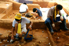
In carrying out excavation investigations and studies of important ruins from the prehistoric and historic periods, the office is attempting to accomplish an accurate restoration of Korean history by presenting reports on site maintenance and restoration as well as research results. Furthermore, investigations of unstable ruins at risk of damage and destruction, as well as of sites likely to receive civil complaints, will also be conducted. Furthermore, investigations of unstable ruins at risk of damage and destruction, as well as of sites likely to receive civil complaints, will also be conducted.
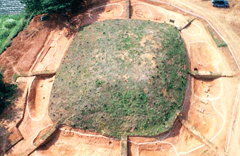
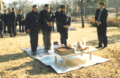
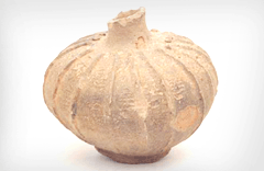
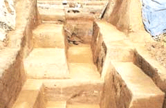
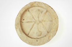
1. Gwangseongbo. (Gwangseongbo Fortification) (Historic Sites)
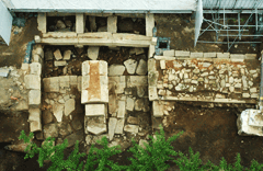
KOREA’S FIRST EXCAVATION OF DONDAE IN GANGHWA-DO, WHICH IS A NATIONAL DEFENSE SITE OF THE JOSEON DYNASTY
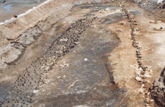
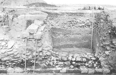
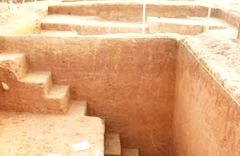
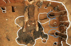
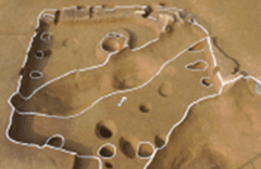
The National Research Institute of Cultural Heritage conducted excavations of Choru Dondae located in the area at the address of San 47, Bukseong-ri, Yangsa-myeon, Ganghwa-gun, Incheon-si.
The excavation of Choru Dondae, a military post inside Ganghwado Fortification, took place as part of a surface survey for historical heritage in that part of the Gimpo area within the DMZ.
Carried out to obtain basic knowledge for the restoration of dondae.
(Military posts with an observation tower for fortification on the frontier) in Ganghwa-do, the excavation took place over 36 days, November 17-December 24, 2003.
This archeological investigation is the first excavation of dondae (fortress) located in Ganghwa-do. By modifying the shortcoming of previous investigations and research,
which concentrated on the surface of dondae, this investigation has provided important data on the construction of dondae.
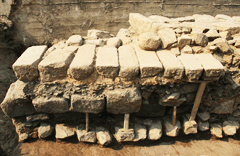
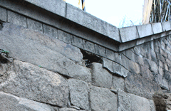
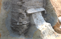
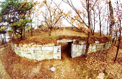 View of the Choru Dondae
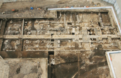
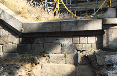
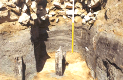
 View after the investigation of gun platform (northwest)
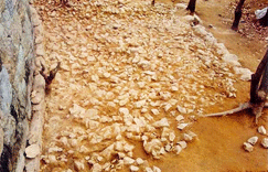
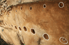
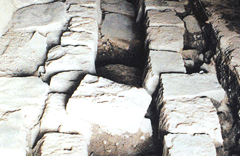
Built with granite blocks on a 45m-high mountain slope, Choru Dondae has an oval shape and measures 35meters from north to south and 27 meters from east to west.
It has three gun platforms along the wall at the north, northwest and northeast, and an entrance at the south. The outside wall of the tower is constructed with rectangular granite
blocks stacked in six to eight tiers on a row of base stones. The upper part consists of boulders in three tiers finished with clay mixed with quicklime.
The survey also revealed that the tower’s south and north walls were built on a layer of weathered rocks buried 30 to 40cm under the ground, while the east and west walls were
built on foundations strengthened by pebbles plastered with clay. Meanwhile, the inner supporting walls were built with stones the size of a human head, gradually narrowing as it
rises up five to six tiers and finished as a two-tier stonewall. The space between the inner and outer walls for the east wall is filled with layers of reddish brown sandy clay,
dark brown sandy clay mixed with charcoal, mud, and tidal mud. For the west wall, the space is filled with layers of mud and sand on a foundation layer of pebbles topped with a layer of sand.
It will serve as important data in understanding the development process of Korean fortresses and related traditional techniques.
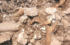
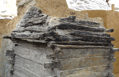
 Soil layer of east wall
 Soil layer of west wall
Unlike the upper part of the outer wall, which was finished with pebbles, the inner wall is finished with two or three tiers of bricks plastered with quicklime.
The stone foundations built on the low ground were reinforced by earth and a layer of fist-sized stones to protect them from damage by rainwater.
Some features of the construction, such as the base stones projecting from the main part of the wall and use of the backfill technique, are typical of Joseon fortress walls,
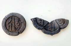
indicating that this military tower was built according to traditional stone wall construction techniques. The excavation team also discovered an artifact bearing an
inscription containing the name of a government post and the date of construction, 1720 (“4th month of the 59th year of Ganghui”).
The results of the excavation of Choru Dondae provided essential information for understanding the construction of Korean battery facilities in Ganghwa-do and its vicinity,
and practical data needed for repair and restoration projects currently underway on the initiative of Ganghwa-gun. It is expected that the findings will lead to better understanding
of Korean defense structures, both in terms of their historical development and technical traditions.
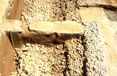
 A rubble stone layer to protect the reinforced soil on the external layer
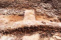
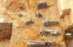
 After investigating a burial mound
(south side)
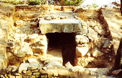
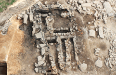
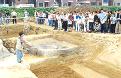
2. Goryeo Tombs in Ganghwa-do. (Historic Site)
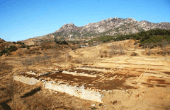
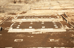
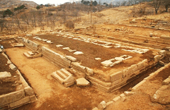
A large array of ancient tombs from the Goryeo Dynasty can be found on Ganghwa-do, including two belonging to kings and two others belonging to queen consorts,
the stone chamber tomb of Neungnae-ri, and the tomb of Heo Yu-jeon, a military official. The National Research Institute of Cultural Heritage carried out excavation projects on some
of the most important of these tombs, such as Seongneung Royal Tomb in 2001, Gareung Royal Tomb and Golleung Royal Tomb in 2004, and the stone-chamber tomb of Neungnae-ri in 2006.
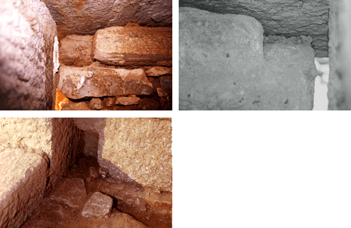
As these ancient tombs share many common features they help us retrace, to some extent, the prevailing style of royal tomb construction when the Goryeo court was temporarily relocated
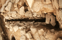
to Ganghwa-do. All are walk-in stone chamber tombs, with the door posts of the chamber entrance at the extremity of the adjoining eastern and western walls and a separate stone piece
on the floor, serving as the threshold. The ceiling is finished with three flat slabs, and there are a series of grooves on the upper and lower edge of the two stone walls adjoining
the entrance, presumably used to fasten the wooden door frame. A raised platform for resting the coffin is placed in the center of the stone chamber, and octagonal stone slabs or
twelve-sided slabs line the upper part of the ceiling. Another common characteristic of these tombs is that the entrance to the stone chamber is blocked by a single large flagstone.
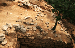
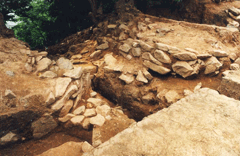
In the case of the stone-chamber tomb of Neungnae-ri, the excavation team identified additional structural components such as stone slabs surrounding the burial mound along its lower
perimeter, a stone railing around the burial mound, support stones for the railing, two stone sculptures of animals, and a low-rising wall around the back of the mound.
All these components were found in their original positions, allowing the archaeological team to fully recover their construction techniques, which, in turn,
will enable complete restoration of the burial mound.
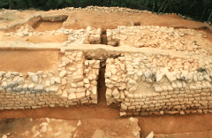
At both the stone-chamber tomb of Neungnae-ri and Golleung Royal Tomb, the excavation team discovered vestiges of a building outside the stone chamber. The building site at Gonngeung,
extending three kan (unit of measurement corresponding to the space between two columns), suggests that there used to be a T-shaped graveyard house, with the middle portion protruding
toward the stone chamber.
As for the Neungnae-ri tomb, two foundation stones have been identified, one each along the front and the side of the building site. At the southern end of the site,
a portion of the stone platform on which the building stood lies exposed with a large stone slab placed perpendicularly at the center of steps, dividing the steps into
left and right halves.
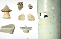
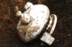
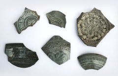
Seongneung Royal Tomb, Gareung Royal Tomb, Golleung Royal Tomb and the stone-chamber tomb of Neungnae-ri had been robbed several times over the years.
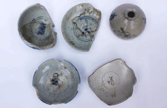
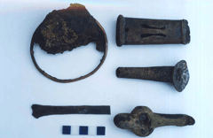
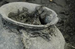
At the time of excavation, however, they still contained large amounts of burial goods, including metal and jade accessories, celadon wares and roof tiles.
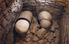
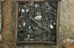
Inside the stone-chamber tomb of Neungnae-ri, a series of jindangu (goods buried to pray for the safety of a newly-constructed building) were uncovered in the four cardinal directions.
The stone-chamber tomb of Gareung Royal Tomb yielded some 100 ancient Chinese coins from the Tang and Song Dynasties and jade jewelry, while Golleung Royal Tomb and Seongneung Royal
Tomb yielded three-footed incense burners and a host of high quality celadon vessels, including a vase lid with simple scroll designs executed with the inverted inlay technique.
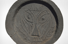
Finally, at the graveyard building sites at Golleung Royal Tomb and the stone-chamber tomb of Neungnae-ri, scores of roof tiles, including convex roof-end tiles bearing ‘goblin-eye’
designs and other decorative roof tiles, were discovered.
Panoramic view of the site (Seongneung Royal Tomb, Gareung Royal Tomb, Golleung Royal Tomb and the stone chamber tomb of Neungnae-ri)

Interior view of the stone chamber (Seongneung Royal Tomb, Gareung Royal Tomb, Golleung Royal Tomb and the stone chamber tomb of Neungnae-ri)

Square hall (Seongneung Royal Tomb, Gareung Royal Tomb, Golleung Royal Tomb)
Stone chamber upper structure (Seongneung Royal Tomb, Gareung Royal Tomb, Golleung Royal Tomb and the stone chamber tomb of Neungnae-ri)

Stone-chamber entrance closure type (Seongneung Royal Tomb, Gareung Royal Tomb, and the stone chamber tomb of Neungnae-ri)
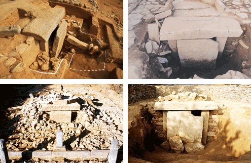
Overall stone chamber building site

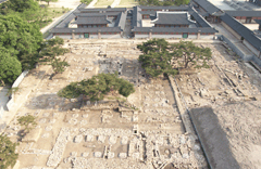
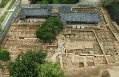
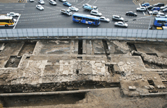
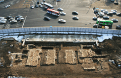
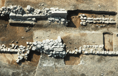
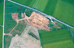
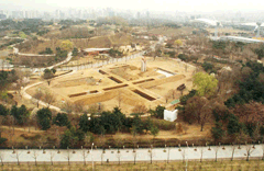
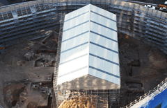
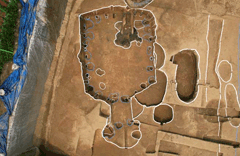
3. Joint North-South Korea Excavation of Goryeo Palace Sites in Gaeseong.
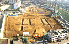
Since 2007, the National Research Institute of Cultural Heritage has been surveying and excavating the sites of Goryeo royal palaces located in Gaeseong,
North Korea, in conjunction with North Korea’s Cultural Heritage Administration Authority and Korean Central History Museum. Between May and November 2007,
a joint North-South Korea archaeology team performed trial excavations on a 30,000m2 area situated west of Hoegyeongjeon, the former throne hall of the Goryeo royal palace Manwoldae,
with actual excavations conducted in some sections. Full excavation was carried out in 2008, over a 50-day period between October and December.
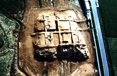
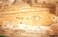
The archaeological investigation found several building sites of different characteristics, forming independent lots, and assembled enough data to determine the layout of the area
lying west of Hoegyeongjeon. Researchers were also able to confirm the structural characteristics of the polygonal building site (shaped like the Chinese character ' 亞 '),
of which little was known until then. In addition, evidence suggests that the site of a building (five kan by three kan) located northwest of the investigation area is that of
Gyeongnyeongjeon, the hall where, according to History of the Goryeo Dynasty (Goryeosa), the portraits of Taejo and other past kings were displayed.
Among the artifacts discovered in the excavation, a 65cm high cylindrical celadon vessel, of a kind never seen before, captured the attention of the archaeological community.
Some 100 roof tiles bearing stamped seal marks, also among the finds, are a rare boon for researchers studying Goryeo roof tiles.
FURTHER JOINT EXCAVATIONS PLANNED OVER THE COMING YEARS ARE EXPECTED TO YIELD NEW POINTERS FOR RESEARCH ON GORYEO PALACES AND CITY WALLS.
 Panoramic view before the investigation (southwest-northeast)
 map
map
 Section view of investigation site (southeast-northwest)
 View of building sites 7 and 18, and the ‘Da’ district garden(south-north)
 View of building site 17 (southwest-northeast)
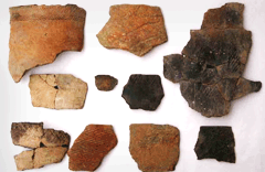
 Excavated pottery batch
 Rubbing of noble family’s stone inscription
 Sanskrit script, roof-end tiles batch
4. Excavation works at Gyeongbokgung Palace.
Gyeongbokgung Palace, which was constructed in the fourth year of the reign of King Taejo (1395), was intentionally modified, as well as damaged, by the Japanese during the period
of Japanese colonial rule. As a result, the Cultural Heritage Administration has sought to restore Gyeongbokgung Palace, the main palace in Seoul, by proceeding with the
‘Gyeongbokgung Palace Restoration and Maintenance Project.’ According to the Gyeongbokgung Palace restoration plan, the Sojubang, Heungbokjeon, Hamhwadang, and Jipgyeongdang sites
were excavated in 2004-2005; while Gwanghwamun Gate, the stone steps, the former palace wall, Yongseongmun Gate and Hyeopsaengmun Gate in the Gwanghwamun district were excavated
between 2006 and 2010. After 2011, an additional excavation of Heungbokjeon site will be carried out.
In 2004, the National Research Institute of Cultural Heritage performed excavation work at the former sites of the Sojubang and Bokhoedang. Sojubang, also known as “suragan,”
was the kitchen of a palace, where meals for the royal household were prepared. The excavation identified three building sites where the inner Sojubang, outer Sojubang and Bokhoedang
used to stand. The inner Sojubang was where meals for the king were prepared, whilst the outer Sojubang was the place in which festive food for memorial services or banquets were made.
Finally, Bokhoedang was a pastry kitchen where beverages, sweets and other snacks were prepared. The excavation work uncovered the drainage system, along with the wells that used to be
the main water supply sources for Gyeongbokgung Palace.
 Panoramic view of the Sojubang Site
 Well site
 Drainage system
A new round of excavation was carried out in 2005, this time at Heungbokjeon Site, Hamhwadang and Jipgyeongdang. Heungbokjeon Site, Hamhwadang and Jipgyeongdang were buildings which were mainly used to receive foreign envoys or hold cabinet meetings. The excavation team detected the vestiges of nine annex units on the lot of Heungbokjeon site and seven annex units belonging to Hamhwadang and Jipgyeongdang. Five house units, dating from prior to the reign of King Gojong, have been also identified during this project. Other discoveries include thirteen floor heating system installations, five threshold panels, twelve drainage duct installations, three chimney installations and two exterior wall foundations.
 Heungbokjeon Site view
 Heungbokjeon Site view
 Hamhwadang and Jipgyeongdang Sites view
In 2006, additional excavation work was done at Heungbokjeon site and annex buildings to Hamhwadang and Jipgyeongdang, and some sections of the area surrounding the Gwanghwamun Gate. This resulted in the discovery of more sewage ducts at Heungbokjeon site, two exterior wall foundations at Hamhwadang and Jipgyeongdang, the site of the southern annex unit of and a house site from an earlier period. As for the Ganghwamun zone, investigation was performed on an area lying north of the archery range in its eastern section, resulting in the identification of one building site, a group of foundation stones and one floor heating system installation.
 Hamhwadang and Jipgyeongdang sites
 Blue tiles excavated from Hamhwadang and Jipgyeongdang Sites
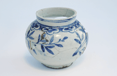 Blue and white porcelain wares excavated from Heungbokjeon Site
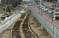
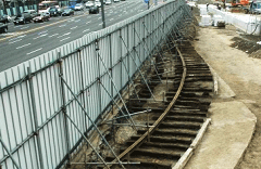
In 2007, a new investigation was launched in the Gwanghwamun area, specifically the area from the former palace walls to the vicinity of the arched hongye gate,
corresponding to the general neighborhood of today’s Dongsipjagak. The archaeological team identified the vestiges of two palace walls (eastern and western Gungjang),
structural remnants of the arch-shaped hongye gate which served as a floodgate and a bridge.
Next, the excavation of the environs of the Gwanghwamun Gate and the palace stone steps led to the discovery of new evidence concerning these edifices and the palace walls,
as well as the structural remnants from the reign of Taejo that were buried below the surface structures. Two house sites from the Joseon Period, streetcar rail paths,
electricity poles and house sites from the colonial era were also identified at this time.
 Gwanghwamun Gate of the King Gojong era
 Yongseongmun site
 Eastern arched hongye gate
In 2008, a new excavation project was carried out in the stretch of former garden walls within the Gwanghwamun zone, extending north to south, from the eastern and western arcades of to the sites of the former palace walls, and the area beginning at the section immediately east of the stone base structure of the Gwanghwamun Gate and ending at Dongsipjagak. The project team discovered, at 40cm below the ground surface, the foundations of garden walls dating from Gojong’s reign, Yongseongmun and the Hyeopsaengmun Sites. The substratum below it, meanwhile, revealed the vestiges of a building dating from an earlier time and more palace walls, all in a very good state of preservation. This project permitted to precisely locate the former sites of the Yongseongmun and Hyeopsaengmun Gates and the palace wall section, east of the Ganghwamun. The palace wall foundations, identified through this project, were in a nearly intact state and provided a good measure as to how grand these walls once were. The discovery of building sites, dating from prior to the Imjin Waeran (Japanese Invasion of Korea in 1592), was also a remarkable accomplishment from this project, casting light on how the palatial architecture evolved in Joseon, in terms of spatial composition (ex. from arcade-enclosed sections to wall-enclosed sections), as well as providing new evidence to reconstruct the image of Gyeongbokgung Palace as a whole.
 Hyeopsaengmun Gate Site
 Details of the western section of the palace burial site
 Site of the guard box for British military officers
In 2009, the western palace wall, the British army guard box, and the officers’ barracks area were excavated. The findings were published in the Report on the Excavation of the Western Palace Wall: Gwanghwamun, which confirmed that the Bukgwol plan drawings were more accurate than the floor plan, as evidenced by the location of the water gate. Along with this evidence, Seosipjagak Tower, mentioned in the Joseon Antiquity Record, was confirmed to be further to the north than originally estimated. Furthermore, through the pictured data, water gates of various shapes and sizes have been identified within the palace wall, and thus the evolution of water gate technology can be assumed. Due to disturbances, no historical reference data useful for the restoration of Gyeongbokgung Palace could be found in the ‘Excavation investigation of the officers’ barracks.’ However, the fact that relics not recorded in the relevant literature are continuously being discovered along with ancestral relics throughout the entire Gyeongbokgung Palace complex is a significant accomplishment. It was of great assistance in reconfirming the need for further excavation investigations of Gyeongbokgung Palace in the future.
 Western water gate
 Yongseongmun Gate
 Eastern palace wall
This archaeological project to excavate the site of the main building of Heungbokjeon Hall and nearby buildings was started in 2012 under the Project for the Restoration of the Heungbokjeon Area of Gyeongbokgung Palace. The project revealed the correct locations and sizes of Heungbokjeon Hall and other associated buildings thanks to the examination of remaining historical materials, including illustrations, although most of the palace building sites, such as Bukhaenggak Pavilion, Junghaenggak Pavilion, Hoegwangdang Hall and Changchabi Hall, were damaged by the construction of a Japanese garden on the site during the Japanese colonial period (1910-1945). The excavation also revealed the archaeological remains of eleven walls, five side entrances, thirteen house walls, six under-the-floor heating systems, two subsidiary buildings, three stairways, and seven drains. The excavation of the site also revealed that Heungbokjeon Hall was built facing in the Jeong Direction, i.e. 165° west of due north, while other associated buildings were designed to face in slightly different directions according to their function, as shown by the Illustrated Report of Korean Cultural Heritage (Joseon Gojeok Bodo, 1933). The stone piles which formed an important part of the buildings’ foundations consist of long rectangles or, more rarely, beveled squares, and generally correspond to the records made when the buildings were rebuilt during the reign of King Gojong (r. 1863-1907).
 Eastern electric tram route
 Western electric tram route
 Seosumunjangcheong area
This archaeological project to excavate the site of the main building of Heungbokjeon Hall and nearby buildings was started in 2012 under the Project for the Restoration of
the Heungbokjeon Area of Gyeongbokgung Palace. The project revealed the correct locations and sizes of Heungbokjeon Hall and other associated buildings thanks to the examination of
remaining historical materials, including illustrations, although most of the palace building sites, such as Bukhaenggak Pavilion, Junghaenggak Pavilion, Hoegwangdang Hall and
Changchabi Hall, were damaged by the construction of a Japanese garden on the site during the Japanese colonial period (1910-1945). The excavation also revealed the archaeological
remains of eleven walls, five side entrances, thirteen house walls, six under-the-floor heating systems, two subsidiary buildings, three stairways, and seven drains.
The excavation of the site also revealed that Heungbokjeon Hall was built facing in the Jeong Direction, i.e. 165° west of due north, while other associated buildings were designed
to face in slightly different directions according to their function, as shown by the Illustrated Report of Korean Cultural Heritage (Joseon Gojeok Bodo, 1933).
The stone piles which formed an important part of the buildings’ foundations consist of long rectangles or, more rarely, beveled squares, and generally correspond to the records
made when the buildings were rebuilt during the reign of King Gojong (r. 1863-1907).
5. Historic Site in Munam-ri, Goseong (Historic Site)
Discovery of vestiges of the oldest Neolithic human remains in the northernmost part of South Korea.
The Prehistoric Site in Munam-ri, Goseong, Gangwon-do is located in the dunes lying in the hilly, southern district, about 400 meters inland from the East Sea coastline.
Archaeological investigations have been undertaken on four separate occasions since 1998. During the first and second (1998 and 2002, respectively) excavation investigations,
some fifteen antiquities including a dwelling site dating to the Neolithic period, burial relics, and, in the outdoor areas, about 1,000 fragments of earthenware and a variety of stone
artifacts were recovered. Recognized for its importance, the location has been designated as the Historic Landmark in Korea. Excavation works are ongoing, with the goal of
developing the Prehistoric Site in Munam-ri into a history education facility. During the 2010 excavation, one dwelling site, two outdoor sites, and western coastal regional-style
deep-engraved earthenware pieces were discovered.
Based on the dating of the relics and artifacts recovered, it appears that the site originates from a time period similar to that of the Historic Site in Osan-ri, Yangyang (6000-3000 B.C.),
which are known to be the earliest Neolithic remains in the country. Furthermore, relics recovered from the lower stratum of the excavation site are deemed to be even older than the
Neolithic Period. The site is therefore considered historically important, as it sheds light on the lifestyles of the Neolithic people throughout northeast Asia ,
including the Korean Peninsula, the three eastern fortresses of China, and the Amur River region in Russia, as well as the cultural system and propagation of that period.
 View of Munam-ri, Goseong
 Excavation view
 Housing site
 Outdoor site
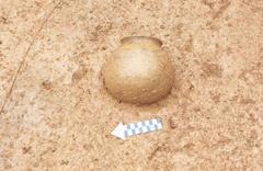
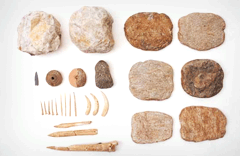
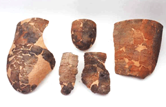
 Relics #02-9
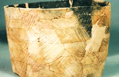
 Okgi of Munam-ri, Goseong
 Various earthenware artifacts
 Various stone artifacts
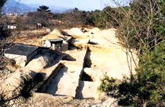
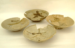
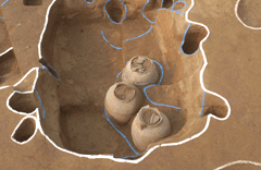
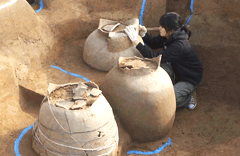
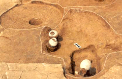
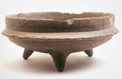
6. Ancient Tomb in Bogam-ri, Naju #3 (Historic Site)
The true nature of the Yeongsangang River basin “apartment-style tomb”
Naju Bogamni Tomb #3 is a flatland tomb located in the field next to the Yeongsangang River at Bogam-ri, Dasi-myeon. Originally, there were seven tombs in the region,
which used to be referred to collectively as ‘Chiljosan (The Seven Tombs)’, although today only four remain. The remaining tombs vary in shape, i.e., circular, U-shaped,
and high-mound types. The third tomb site is of the high-mound type.
As a result of the three phases of excavation investigations conducted between 1996 and 1998, it was discovered that the clay coffins indigenous to the area were buried in stone-chamber
tombs, the style of which is native to the early Yeongsangang River basin area.
The tombs are symbolic of the process by which indigenous groups of people were incorporated into Baekje, and thus constitute an important historic site. In addition,
the forty-one tombs found in the Yeong-sangang River region include jar tombs, wooden tombs, stone hole tombs, stone chambertombs with tunnel entrance, stone-chamber with front
opening tombs, and stone-lined tombs. These examples yield important data about the tomb styles employed from the 3rd to 7th centuries. By realizing that, in order to construct
a high-mound type of tomb, two or three Seonhaeng tomb mounds had to be organized and combined, this archaeological research investigation provided important information regarding
the methods of tomb construction employed in the region, as well as highlighting the manner by which regional native people were assimilated into and adapted to Baekje culture.
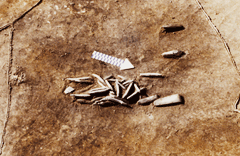
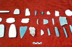
Besides the tomb-related contents, numerous decorative items such as gilt bronze shoes, silver thread accessories, and knives - important relics which attest to the interactions
and relation-ships between Baekje, the Yeongsangang River Valley, and Waero – were excavated.
They have also helped to breathe vitality into the archaeological and historical research studies of the Yeongsangang River valley region.
 View of the Ancient Tombs in Bogam-ri
 View of the investigation at Bogam-ri, Naju
 Interior view of Stone Chamber No. 96 in Bogam-ri, Naju
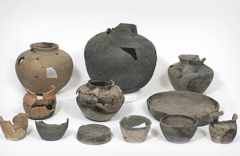
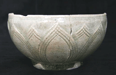
 Earthenware excavated at Tomb No. 3 in Bogam-ri, Naju
 Gilt bronze shoes found in Stone Chamber No. 96, Tomb No. 3 in Bogam-ri, Naju
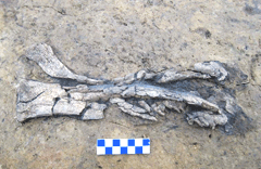
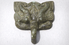
 Snaffle {bridle bit} found in Stone Chamber No. 96, Tomb No. 3 in Bogam-ri, Naju
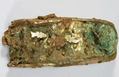
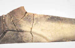
 Gold and Silver(knife) found at Tomb No. 7 in Bogam-ri, Naju
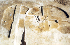
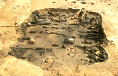
7. Ancient Tomb in Sinchon-ri, Naju #9 (Historic Site)
Large, central tomb complex in the Yeongsangang River valley
Ancient Tomb in Sinchon-ri, Naju #9 is representative of the Onggwan (clay coffin) tombs of the Yeongsan-gang River valley and is located in the Bannam-myeon region of Naju-si, Jeollanam-do. Within Bannam-myeon, there are thirty ancient tombs scattered throughout the Sinchon-ri, Deoksan-ri and Daean-ri areas. Of these, the central Tomb No.9 is the only high-mound type, the others being either circular or U-shaped. Tomb No.9 in Sinchon-ri was studied by Japanese researchers more than eighty years ago (1917-1918), and at that time, eleven clay coffins, a gilt bronze crown (National Treasure), gilt bronze shoes, and a large-hook knife were excavated, and received a great deal of attention. However, due to the circumstances of that period, the analysis of the relics was distorted and the results of the research were not properly reported, creating many difficulties for subsequent research efforts.
The re-excavation conducted in 1999 is recognized as an important archaeological dig due to its successful identification of the prehistoric society that existed in the Yeongsangang River valley. During the work, cylindrical earthenware objects of different heights arranged in a row were discovered at the top and in the middle of the burial mound, in what is thought to be the first arrangement of this kind, although cylindrical earthenware artifacts had already been excavated near the Yeongsangang River valley, including the Ancient Tombs in Myeonghwa-dong, and Wolgye-dong of Gwangju. Therefore, the position of these linearly-arranged earthenware artifacts provided clues to their function. These cylindrical objects are similar to the wontonghaniwa (cylindrical clay wheels) found in ancient Japanese burial mounds, thus providing an important clue as to the ancient links between Korea and Japan. However, they exhibit a different shape, production technique and façade to the Japanese haniwa(clay figurines of the Kofun period), which suggests they were produced locally from borrowed ideas.
The ditches of varying depths that surround the burial mound are presumed to have served as a means of gathering the soil required to build the mounds. By examining the soil strata both above and below the clay coffin and the arrangement of the cylindrical earthenware objects, it is thought that the burial mound had been extended vertically more than once - a significant piece of data for surveying the characteristics of burial mound construction in this region.
The excavation of Tomb No.9 in Sinchon-ri, Naju despite being somewhat limited due to the unclear work practices employed eighty years ago, yielded new information about the method of building burial mounds, the structure of burial sites, and the arrangement of cylindrical earthenware artifacts. Furthermore, it is a great accomplishment to have identified the active and aggressive response of the people of the Yeongsangang River valley during this tumultuous period of history; the introduction of cylindrical earthenware in the unique style of the Yeongsangang River valley; and Baekje’s cultural influence in Bannam Ancient Tombs.
 View of ditch
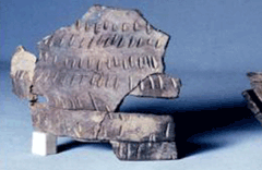
 Exposed condition of a row of cylindrical earthenware objects
 Cylindrical earthenware objects
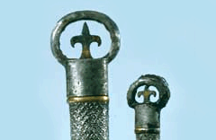 Ring-pommel Sword, excavated in 1917
 Bunjeong investigation area
 Exposed condition of a row of cylindrical earthenware objects
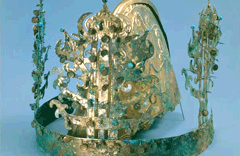 Gilt-bronze Crown excavated in 1917
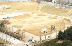
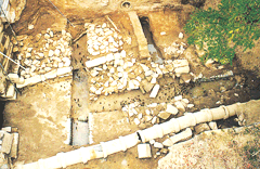
8. Excavation of the site of former Seoul Olympic Art Museum and Sculpture Park.
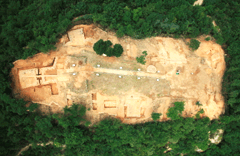
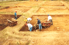
The National Research Institute of Cultural Heritage carried out a field survey on the site of the Seoul Olympic Art Museum and Sculpture Park when plans were announced to erect a new museum building and underground parking lot and renovate the sculpture park. The survey of the site, measuring 110,200m2 and located in Olympic Park in Bangi-dong, Seoul, was carried out using the grid and trench methods between January and June 2002.
A surface survey was conducted in this region bordering the southern extremity of Mongchontoseong, an important earthen-wall fortress from the Baekje Period, designated as Historic Site, confirming the need for trial excavation. A joint project committee was subsequently created with members from two subcommittees of the Cultural Heritage Committee to steer a preliminary excavation on the outskirts of the fortress. The goal of this project was to uncover structures likely to have been located in and around the fortress including a moat, structural features of the fortress walls, and house and grave sites.
The survey revealed that the area contains archaeological layers from the Baekje Period in the hilly eastern part of the site. However, the layers were not deep and did not produce a notable amount of artifacts, leading to the conclusion that no significant group of dwellings had been located on the site. The low lying western part of the site comprised a mud layer over 3 meters deep containing no artifacts, indicating that this area formed a natural wetlands area long before Mongchontoseong was built.
Meanwhile, the site of the sculpture park was found to consist of a wide open plain in the west and a hilly area in the east. Trench digging revealed a mud layer that shed light on the original topography of the land before the construction of the Olympic Park, as well as archaeological layers of the Baekje Period and dwelling sites and structural features.
The site consists of hilly slopes on three sides with the fortress located on the northern side. The plain, surrounded by gentle hills, sloped down from east to west before it was filled 2 to 3 meters for the construction of Olympic Park. On a slope near the eastern hills, the excavation team discovered a square dwelling site and pit structures from the Baekje period as well as a large mud layer in the lowland within the hilly area. The shape and size of the layer led the team to believe that it was a reservoir made for agricultural use rather than a moat to protect the southern part of the fortress, an idea reinforced by the fact that no traces of a moat were found in trench surveys for other parts of the fortress walls.
The eastern hilly area was found to have extended wide from east to west and from south to north. Researchers believe that the topography was similar in the Baekje period, but excavation revealed that while the south-north hill maintained its original state, the east-west hill was built up when the park was constructed. It was concluded that much of the site containing Baekje artifacts was gravely damaged during construction of the park. However, the southern end of the south-north hill retains the Baekje archaeological layer where many artifacts such as small short-necked jars have been discovered. Researchers concluded that the site of the new museum and sculpture part most likely included Baekje dwellings, but most of the site has lost its original state.
In sum, the excavation team found that the site of the new art museum and sculpture park and the surrounding lowland contained no archaeological traces related to Mongchontoseong such as a moat, group of dwellings, or tombs.
Except the Mongchon Earthen Ramparts on the north, the three sides of the Great Plains are surrounded by low mounds. The plains slope from east to west; 2~3m of the plains was buried during the construction of the Olympic Park, forming their current appearance. In particular, from the slope area near the mound on the east side, a room-shaped residential area and the round pits of the Baekje period were discovered. From the low land located within the hill areas, wide mud layers that get narrower toward the west were discovered. Judging from the shape and size of the mud layers, the area seems to have been used as reservoir for storing water for farming during the Baekje period rather than as trenches surrounding the south side of the Mongchon Earthen Ramparts. This assumption is also supported by the fact that no clue proving the possibility of trenches was discovered during an investigation of trenches near the walls of the Mongchon Earthen Ramparts.
 Olympic Art Museum Site
 Gaetoje
 View of the ruins at the Olympic Art Museum
 Olympic Art Museum A-district Site
 Olympic Art Museum B-district Site
The mounds on the east side are distributed quite extensively from east to west and from north to south. They are presumed to have similar geographical features during the Baekje Period. According to the results of excavations, however, the mounds stretching from north to south were constructed into their present shape by shaving off their original topological shape, whereas the east side of the mounds stretching from east to west seems to have been formed by man. Accordingly, a vast portion of this area was damaged during the construction of the park, destroying most of the cultural layer of the Baekje Period. From the valley area belonging to the south end of the mounds stretching from south to north, however, some layers containing relics from the Baekje Period were discovered, and small jars with short neck and several other artifacts were excavated; hence the high likelihood that residential areas of the Baekje Period might have existed in this area. At present, however, most of the original shape is destroyed.
Based on the results of investigations, it can be concluded that neither traces of trenches related to the Mongchon Earthen Ramparts nor collective residential areas or grave sites were discovered from the site of the Olympic Art Museum and Sculpture Park. The low land surrounding the mounds might have been used as reservoirs for farming or natural wetland for a long period of time.
 Exposed cover of Sejangbanghyeongsuhyeolbu
 Exposed view of small long-necked jar
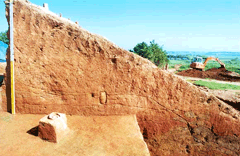
9. Excavation of the Sungnyemun Gate, Seoul, Seoul.
An excavation project to gather archaeological evidence for the restoration of Sungnyemun Gate, Seoul, Seoul, consumed by fire in February 2008, was carried out over three years from 2008 to 2010. With the objective of restoring the south gate of Joseon’s ancient capital to its original appearance, excavation work was planned across the entire area immediately surrounding the gate, including the two adjoining sections of the old city walls and the neighboring area.
Investigations by each year are as follows: areas within a 10-meter range from Sungnyemun Gate, Seoul, Seoul, inside and outside the city walls, were investigated in 2008; the section of the city walls adjoining the left side of the gate and the area near the foundations of the gate were excavated in 2009; and other sections in the immediate vicinity of Sungnyemun Gate, Seoul, Seoul, Seoul were excavated in 2010.
As a result of the investigation, the existence of a road passing through Sungnyemun Gate, Seoul, the building sites, and the foundations of city walls to the left and right of the gate was confirmed. In the areas within a 10-meter range of Sungnyemun Gate, Seoul, Seoul, inside and outside the ancient capital, whose excavation was completed in 2008, the NRICH archaeological team identified traces of a road, paved during the late Joseon Period, running through the gate, building sites, and the foundations of the left and right adjoining walls.
The road, paved over foundations made up of six to eight layers of brown sandy soil, was covered with rather large irregular stone slabs (measuring 110 x 100 x 10cm on average). Overall, highly sophisticated techniques were used for the construction of this road. Meanwhile, the building sites uncovered in 2008 cover a wide-ranging period, from the early Joseon Period (circa 16th century) to the late Joseon and the Great Han Empire Period (19th to early 20th century). Some remnants of drainage and heating systems were also identified at the same time. The walls adjoining Sungnyemun Gate, Seoul, Seoul to the right and left were modified to their current appearance during the Japanese occupation period (1910-45). That is, the upper portion of the walls was cut off, leaving an oblique edge. It was, however, confirmed that the foundations of the two walls below the ground remained intact in their original state. Below the small square stones (30-40×20cm) exposed at ground level, three to four layers of large rectangular stones rested on alternate strata of rubble and sandy soil. The walls, so built, reached a height of 210-240cm.
 View after the investigation of Sungnyemun Gate, Seoul, Seoul
 Korean under-floor heating system around Sungnyemun Gate, Seoul, Seoul
 White porcelain incense burner excavated at Sungnyemun Gate, Seoul, Seoul
 Grayish-blue-powdered celadon excavated at Sungnyemun Gate, Seoul, Seoul, Seoul
 View of western city wall construction at Sungnyemun Gate, Seoul
 View of eastern city wall construction at Sungnyemun Gate, Seoul
 The arch-stone appearance of Sungnyemun Gate, Seoul
 Blue and white porcelains excavaed from the site of Sungnyemun Gate, Seoul
10. Excavation of Fort No.4 in Achasan Mountain No. 4.
Four Forts in Achasan Mountain are is situated on the northernmost peak (284m above sea level) of a ridge of Achasan Mountain running north to south through an area extending from Acheon-dong, Guri, Gyeonggi-do to San 1, Junggok-dong, Gwangjin-gu, Seoul.
The interior of Fort No. 4 was first examined in 1997-1998 by an archaeological team of the Seoul National University Museum, which uncovered seven building sites, two water reservoir sites, the traces of 13 under-floor heating installations (ondol), and a makeshift blacksmith shop. A large array of Goguryeo earthenware and iron tools were also discovered at this time.
Several years later, the city of Guri, as part of a maintenance project, requested that the National Research Institute of Cultural Heritage conduct further excavations to make up for any shortfall in the first study and to look for the foundations of the fortress walls. The NRICH excavation, carried out over five months between May and October 2006, resulted in the discovery of the site of four turrets and one dual-structure turret and the traces of a drainage system and five ondol heating systems. The site of the dual-structure turret was found near the southern edge of the archaeological site. The turret presumably functioned both as a watchtower and entrance to the fortified town, and is an important discovery that will stimulate research on Goguryeo fortifications.
 View of Achasan Fort No. 4
 Post-investigation view of wooden structure located to the west of Achasan Fort
 View of the east wall at Achasan Fort
 View No. 2 of the east wall at Achasan Fort
 View of twin turret
 View of twin turret
11. Excavation of Naksansa Temple in Yangyang.
In 2006, the National Research Institute of Cultural Heritage followed up its initial excavation investigation (2005-2006) with a second excavation, during which the Wontongbojeon Hall area was surveyed, shedding light on the original layout and size of this ancient building.
The evidence gathered in the second excavation suggests a terrace-like layout, with buildings arranged in three tiers. It was confirmed that Wontongbojeon was situated on the first of the three tiers, while two buildings facing each across a courtyard stood on the second tier. Another building, whose long side ran east to west, sat at the southern edge. Finally, the site of a gatehouse was discovered on the third and lowest tier.
Artifacts discovered through this project span a vast period of time, from Unified Silla to Goryeo and Joseon, and include roof-end tiles, roof tiles and fragments of pottery. However, no architectural remains related to these artifacts were identified in the area investigated. Hence no new information was obtained on the layout of this Buddhist temple prior to late Joseon, that is, from the time of its initial construction through to the Goryeo and early to mid-Joseon periods.
It is deemed likely that the buildings located in the area immediately surrounding the main hall were burnt down and rebuilt several times during the late Joseon Period, over the same foundations, but were completely burnt down during the Korean War in 1950.
The layout of Naksansa Temple as reconstructed through this excavation project is very similar to that seen in a 1778 painting of the same temple by Kim Hong-do. This painting titled "Naksansado" is one of a series of landscapes commissioned by King Jeongjo, for which Kim Hong-do traveled to Mt. Geumgangsan and other scenic sites in central and eastern Korea. This layout is also partially echoed in other 18th century paintings of Naksansa Temple by artists such as Jeong Seon or Kim Yu-seong. The significance of the second excavation of Naksansa lies in the fact that the layout of this ancient Buddhist temple retraced by archaeological evidence is almost identical to that documented by 18th-century paintings. These paintings of Naksansa are also considered important references for restoration of the temple to its original appearance.
 Post-investigation view of Naksansa Temple
 Naksansado (Kim Hong-do, 1778)
 Roof tiles excavated at Naksansa Temple
 Valuable white porcelain excavated at Naksansa Temple
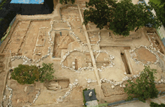
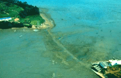
12. Historic Site of Cheonghaejin Fort, Wando (Historic Site)
Archeological investigation of the Historic Site of Cheonghaejin Fort, Wando Naval Garrison site in Jangdo Island in relation with marine activities of Emperor of the Sea Jangbogo
The National Research Institute of Cultural Heritage conducted archeological investigations of the Historic Site of Cheonghaejin Fort, Wando (Historic Site), which is located in Jangjwa-ri, Wando-eup, Wando-gun, Jeollanam-do, in relation with the naval activities of “Emperor of the Sea Jangbogo”; and reported their research results.
Since 1991, the National Research Institute of Cultural Heritage has conducted eight excavations on Jangdo Island with a view to gathering information about the naval garrison Historic Site of Cheonghaejin Fort, Wando. During the first six excavations, the investigation team discovered the remains of an 890-meter-long earthen fortress wall, which was built with a panchuk (hardening and heaping) technique, and various building sites lying within it, including a 331-meter-long wooden structure, as well as over 30,000 artifacts, providing evidence that Jangdo was an important base of Historic Site of Cheonghaejin Fort, Wando.
 Water’s edge between Jangdo Island and inland
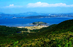 View of Jangdo Island from inland
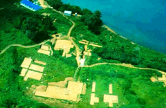 View of the ruins
 Wooden structure
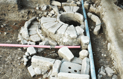
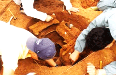
In the seventh excavation carried out in 2003, researchers discovered more important remains related to the maritime activities of the military commander Jang Bo-go, including a well site and a U-shaped stone embankment believed to have functioned as the pier.
The excavations produced decisive evidence that the Historic Site of Cheonghaejin Fort, Wando headquarters was in fact located on Jangdo. The eighth excavation was focused on the U-shaped stone embankment discovered on the coast, and the well site. In addition, the team made several new discoveries including an underwater wooden barricade beside wooden structures found in an earlier excavation, as well as a drainage channel around the fortress wall. They also found that Both the inner and outer walls of the earthen fortress were built on foundations comprising a row of stones in two tiers.
The U-shaped stone embankment, measuring 21 x 22m, consist of inner and outer rows of foundation stones, the gap filled with stones and stamped earth heaped on it. It is a coastal defense structure of a kind that has not been found in China, Japan or Korea.
 View of excavation site south of the shrine
 View of the exposed fortress wall
 Drainage system
 View of the buried relic excavation site
This 6m-deep well was built by laying a '井'-shaped log at the bottom to establish the foundation and by stacking stones on top. The top and bottom parts of the well are narrow (diameter: 150cm), while the mid-section is a little wider (diameter: 180cm). A layer of pebbles about 50cm thick was laid at the bottom to purify the water.
Numerous relics have been found at the bottom of the well, including earthenware objects such as four-sided flat bottles and wave-pattern bottles; metal artifacts such as muzzles, adzes and rings; and other relics such as fishnet sinkers, spindle whorls, and flint stones. In particular, four flat bottles with broken mouths were also excavated there. They were probably buried in the well intentionally at the time of its construction. The discovery of these artifacts proves that the well was built in almost the same period as Historic Site of Cheonghaejin Fort, Wando Fortress. It was probably used to supply water to a ship commanded by Jang Bogo, as well as to Historic Site of Cheonghaejin Fort, Wando.
 Well
Well
 Bronze jar
 Pleat-patterned jar
 Flat bottle
On lowlands to the west of Jangdo, NRICH researchers also found a culvert style drainage channel at the fortress wall site with flagstones laid at the bottom and filled in with rubble, as well as a funnel-shaped entrance designed to channel the flow of rainwater to the drain. The structure offers important clues to understanding the drainage system used in panchuk-style earthen fortress wall.
As the above shows, the artifacts excavated at the Jangdo site provide important basic materials for the study of Historic Site of Cheonghaejin Fort, Wando as the base of Jang Bo-go and his maritime activities. Also, the artifacts dating to the first half of the 9th century or earlier discovered on the island are useful "indicators" of the Unified Silla Period.
 Metal relic excavated from the well
 Flat bottle
13. Excavation of Midwest Islands - First archaeological excavation of Neolithic sites in the five islands of the West Sea.
The islands of the central western coastal region, including Baengnyeongdo and Yeonpyeongdo islands, are recognized as sites that provide valuable insights into the fishing and other maritime activities of the Neolithic period. As such, the need to excavate the area has been consistently expounded.
On the other hand, the National Research Institute of Cultural Heritage compared a report titled Comb-pattern Pottery Sites of Baengnyeongdo and Yeonpyeongdo, published by Seoul National University in 1982, with another report titled Surface Survey Report on Archaeological Sites within Restricted-Access Military Zones, published in 2001. As a result of this comparative study, the Institute confirmed that due to a combination of artificial and natural factors, only nine of sixteen shell mounds remained and even those were suffering from rapid erosion and other damage.
 View of ruins on Soyeonpyeongdo Island
 Grounds within the residential area at Shell Mound on Moido Island, Seohae
 East West view of Shell Mound at Kkachisan Mountain, Daeyeonpyeongdo Island, Seohae
 Conditions of the grounds and excavated animal bones at the Shell Mound at Kkachisan Mountain, Daeyeonpyeongdo Island, Seohae
In order to establish measures for the preservation of the ruins and to gain a better understanding of the area, the National Research Institute of Cultural Heritage proceeded with an excavation investigation of the sites most at risk of damage and destruction. This effort resulted in the excavation investigations of the Soyeonpyeongdo Island Shell Mound in 2000-2001, of Daeyeonpyeongdo Island in 2002, and of Kkachisan Mountain, Daeyeonpyeongdo, in 2003.
 Earthenware excavated from shell mounds in Kkachisan Mountain of Daeyeonpyeongdo Island in the west coastal region
 Earthenware excavated from shell mounds in Soyeonpyeongdo Island in the west coastal region
 Various artifacts such as stone fishing-net sinkers excavated from Shell Mounds at Moido Island, Seohae
 Earthenware excavated from shell mounds in Moido Island in the west coastal region
At Soyeonpyeongdo Island, the existence of two separate strata of shells was confirmed. The strata were divided into seven layers, two of which were identified as shell strata from the Neolithic period. The shell strata formed immediately below the humus stratum. From the hillock below the shell strata, a dark brown clay stratum and an ochre sandy soil stratum were deposited, suggesting that these two layers formed around the same time as the shell strata.
Most of the Neolithic artifacts discovered from this site were deep earthenware bowls, but also included some pottery jars and bowls. The number of pottery jars increased toward the upper strata. The patterns such as fishbone patterns, slanted line patterns, lattice, diamond and dotted patterns, found on the recovered items proved to be more varied toward the upper strata also. The increasing variety of decorative motifs was also accompanied by a growing trend toward plain pottery. The pottery found in shell mound No. 2 shows a greater variety in terms of both vessel type and decorative motifs than that in shell mound No. 1, and is likely to have been used over a longer period than the latter. However, it is also possible that the two shell mounds were used for two different purposes, given that the shell layer in mound No. 1 was much thicker than that in No. 2, even though it contained less pottery.
Within the ruins, earthenware artifacts relating to the coastal region of the western coastal and the southern inland region of the Korean Peninsula have been excavated: they are now valued as important data that provide evidence of the cultural relationship that existed between the two regions.In addition, some 300 fishing net sinkers, fish bones, and large earthenware storage vessels have been excavated.
Radiocarbon dating of the shell revealed that the first shell mound dates back to 2860-2280 BC and the second shell mound to 2860-2400 BC (95% reliability), corresponding to the late-mid to early-late period of the Neolithic Age.
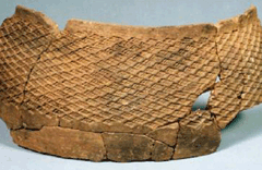
 Comb-patterned earthenware excavated at the shell mound
 Comb-patterned earthenware excavated at the shell mound
 Flat-bottomed earthenware excavated at the shell mound
In the shell mounds located on Moido and Daeyeonpyeongdo Island, a shell stratum with a diameter of about 15 meters and a maximum thickness of 6 meters was discovered. The cross section of the shell strata shows sequential sedimentation.
Two Neolithic Age dwelling sites and eight outdoor fireplace sites have also been identified. The dwelling site was well organized, showing signs that all shell sedimentation had been removed and a stone foundation laid. It was also noted that gastroliths were discovered within the dwelling area.The Muido shell mound on Daeyeonpyeongdo Island contained a large number of stone tools, which distinguishes it from other shell mound sites in west coast areas of the central region. Also noteworthy is the discovery of stone arrowheads, which are rarely found in shell mounds. Meanwhile, the deer antlers found inside this shell mound suggests that the Neolithic inhabitants of this area were not just fishermen but hunters as well.
Finally, in the Kkachisan shell mound on Daeyeonpyeongdo Island, the excavation of an area of about 165m2 uncovered four strata containing Neolithic artifacts. One dwelling site and five outdoor fireplace sites were also identified. A layer of brown alluvial clay soil, formed by the soil running down from the top of the hillock, was found across the entire area investigated. Taken a reference point, this layer was helpful in distinguishing different strata of sedimentation formed above and below in chronological order, which, in turn, permitted the establishment of a more precise timeline for comb-pattern pottery.
The artifacts gleaned from this site were very distinct to those found in other Neolithic sites in central western Korea. Unlike pottery found on the central western coast, which mostly bear incised fishbone designs, the vast majority of pottery discovered at this site bore impressed slanted line designs, or diamond and wave designs. This suggests that the Kkachisan shell mound has a close connection to the nearby Hwanghae-do region and that comparison of the pottery found here with the comb-pattern pottery found in North Korea could reveal interesting similarities. Furthermore, earthenware featuring a combination of three incised patterns, earthenware with incised fishbone designs, and earthenware made from clay mixed with talcum and asbestos were also discovered at this site, which indicates that the site predates other Neolithic sites in the central western coastal area. Also significant was the discovery of a large amount of mammal and bird bones inside the shell mound, along with the traces of fireplaces.
Such evidence that the Neolithic inhabitants of this area were not just fishermen but also hunters may cast important new light on the way of life of inhabitants of the Korean peninsula during this period of prehistory.
 Flat-bottomed earthenware excavated at the shell mound
 Pressed-down pattern earthenware excavated at the shell mound
 Pressed-down pattern earthenware excavated at the shell mound
 Bone gimlet and various animal bones excavated at the shell mound
The vast collection of artifacts discovered through the above-described excavations will contribute to research on the Neolithic culture that developed in central western coastal areas of the Korean peninsula, long stunted due to the dearth of archaeological data, by helping researchers in this field reconstruct the evolution of pottery making and the way of life of the prehistoric inhabitants of this region. The NRICH intends to establish concrete protection plans to safeguard Neolithic shell mounds on the west-sea islands, which have not benefited from any preservation efforts thus far, from deterioration caused by human activities as well as the threat from the elements.
14. Excavation of Geumcheongyo Bridge of Changdeokgung Palace.
Built in 1411 during the reign of King Taejong, Geumcheongyo Bridge of Changdeokgung Palace is known to be the oldest stone bridge in any Joseon royal palace. Currently, the bridge is located horizontally to the north of Jinseonmun Gate. But historical records including Donggwoldo‘Illustration of the Eastern Palace’ suggest it was located in a straight line from the gate, reigniting arguments that the bridge was moved from its original location during Japanese colonial rule.
The excavation investigation of theGeumcheongyo Bridge of Changdeokgung Palace Site was carried out in two phases, in 2001 and in 2002.
The results of the investigation showed that the identified drainage system, located within two arched doors under Geumcheongyo Bridge of Changdeokgung Palace Bridge, measured 10 meters in length and 2.4 meters in width.The foundations for the southern side of the bridge were constructed by laying down gray mud and covering it with a layer of sand between 30 and 40cm thick, foundation stakes and rubble piled up in two to three layers. Among the relics discovered during the excavation were a number of celadon and white porcelain shards dating from the 15th ~ 16th century, white porcelain shards from the 19th century, and some Japanese porcelain fragments.
 View of the ruins after initial investigation
 Stonework of the southern water gate of Geumcheongyo Bridge of Changdeokgung Palace – view of the eastern wall cross section
 Drainage facilities at the eastern arched door of Geumcheongyo Bridge of Changdeokgung Palace
 View of the stake
 North-south seogyeol ruins (western part of Geumcheongyo Bridge of Changdeokgung Palace)
 Wooden finishing elements for pumice facilities (extended area east of southern part of Geumcheongyo Bridge of Changdeokgung Palace)
 Stone masonry
 View of Jinseonmun Gate from modern-day Geumcheongyo Bridge of Changdeokgung Palace
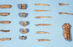
15. Remains of the Paleolithic era in Gawol-ri and Juwol-ri in Paju. (Paju gawolli mit juwolli guseokgi yujeok) (Historic Site)
Confirmation of the large site of Paleolithic Age in the Korean Peninsula, along with Jeongok-ri
Located on a hill running along the eastern part of the Imjingang River, the Geumpa-ri Site was excavated during four projects held between 1989 and 1992.The excavation projects produced a total of over 2,400 artifacts including hand axes, circular cleavers, polygonal implements, choppers, cores and flakes.
 View of the ruins
 Investigative process
 Cross section of the soil stratum
 Stoneware
The discovery of this site revealed human existence in the Imjingang River estuary in the Quaternary Period of the Cenozoic, and provides a comprehensive look at the lifestyle of early human beings and their efforts to adapt to the environment.
 Stoneware
 Stoneware
 Stoneware
 Stoneware
 Stoneware
16. Earthen Fortification in Pungnap-dong, Seoul (Historic Site)
Excavation of earthen fortification which can prove the existence of the Great Baekje Dynasty
Following the confirmation of Earthen Fortification in Pungnap-dong, Seoul (Historic Site) as a flatland earthen fortress based on an archaeological excavation conducted between 1997 and 2000, a ten-year research plan starting in 2003 was established, and the site is now being excavated as part of an undertaking aimed at transforming historic sites into parks. In addition, the excavated materials will be displayed at the Youth Cultural Experience Village Exhibition Hall.
 Pre-investigation view of Pungnaptoseong Fortress
 Site information session
 Piling condition of the earthen wall cross section
The excavation investigation of the fortress wall conducted by our research team in 1999 sought to secure the basic information necessary for the restoration and maintenance of Earthen Fortification in Pungnap-dong, Seoul, and was, incidentally, the very first investigation of the fortress wall. Two spots, A and B, were selected and the fortress wall was cut by penetrating through the thickness of the wall via a section measuring 50m x 10m.
The excavation revealed that the walls of Pungnaptoseong were built by piling up stamped mud at a slant to form the main part of the wall structure, then reinforcing the upper part with stones stacked in rows, and finally filling the inside with plant matter. This is the earliest known method for building mud fortification walls discovered in Korea. Experts believe that discoveries from the excavation will provide valuable resources for study of the early Baekje capital in the Hanseong Period, as well as the techniques and spread of earthen-wall construction in the region.
 Current condition of the lumber and muddy layer below the stonework
 Current condition of the plant material, organisms and lumber
 Current condition of the lumber structures
 Three-layer stone row and stonework
 Excavated artifacts
17. Excavation of the Archaeological Site at 197 Pungnap-dong, and Discovery of An Early Baekje Road.
Gradual Discovery of the Structure of Baekje’s Capital City
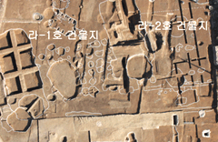
As part of a ten-year plan by the National Research Institute of Cultural Heritage to gather archaeological evidence related to Earthen Fortification in Pungnap-dong, Seoul, an early Baekje fortification, an excavation survey of the area around 197 Pungnap-dong (Mirae Village) was conducted from 2004 to 2011. As a result of this investigation, 543 sites comprising roads, a large graveyard, buildings, residential areas, and other ancient structures dating back to the Hanseong Baekje Period (18 BC - 475 AD) were identified. The road, extending some 123 meters, was packed down with sandy soil and river gravel, and traces of drainage ducts were also discovered along the roadside. The identified dwelling sites can be classified into the following three large categories: flat ‘凸(呂)’ shaped dwellings; mid- to large-size hexagonal dwellings with separate entrance areas; and small, flat square dwellings.
From the flat ‘凸(呂)’ shaped dwellings, hard-fired, pattern-less earthenware and nangnanggye earthenware were excavated, but no pottery vessels from the late Hanseong Period - such as three-footed bowls, mounted dishes, plates or dish stands - were discovered in the hexagonal dwelling sites. Meanwhile, the fireplaces in the flat ‘凸(呂)’ shaped dwellings often had ㄱ-shaped floor heating systems and a bare floor; the fireplaces in the hexagonal dwelling sites seem to have had a long smoke duct, often touching the northeastern wall, while the square dwelling sites had a much shorter smoke duct, and a 八-shaped floor heating system, which points to a possible chronological difference between these two types of housing, or a difference in the social status of their inhabitants.
In the northern area of the investigation site, more large series of rectangular pits rather than dwellings were identified. Traces of the existence of wooden crates or the remains of large jars found in these pits suggest they might have served as storage areas. Furthermore, they exhibit many similarities with the wooden-crate storage room of the Gwanbuk-ri historical site in Buyeo. The latter site, a storage area for food supplied to the royal palace, is presumed to be the prototype for the wooden-crate storage facilities of the Sabi Period.
The discoveries from this site include Baekje pottery items such as high-fired plain stoneware, egg-shaped earthenware, mounted dishes, and stands, as well as silver earrings similar to the gold earrings unearthed in the Nohasim Historic Site from the Buyeo Period. Also figuring among the finds were a bronze ornament from China, a celadon dish with a raised and incised lotus design, and convex roof-end tiles with lotus designs showing the influence of Northern Wei, all of which provide important clues about Baekje's exchange with neighboring Asian countries. In particular, after a great number of Baekje Hanseong Period's roof tiles were excavated at a large roof-tile waste pit in 2005-2006, thousands of roof tiles of Hanseong Baekje Period along with the associated building sites were excavated in 2010-2011. These findings constitute an invaluable source of excellent data for researchers’ studies on the roof tiles of the Korean Peninsula.
 Aerial photography of Na district, 2008
 Wood-burning stove at the Na-10th dwelling
 View of the Na-10th dwelling
 State of skeletons recovered within the Na-10th dwelling site
 Group of artifacts excavated at the Na-10th dwelling site
 Completion of investigation of 38th pit
 Celadon dish with raised and incised lotus design
 Catcher
 Large jar at the Pungnap Mirae Village Storage facility
 Ra-2nd dwelling site
 Exposed condition of dwelling charcoal at Ra-2nd
 Exposed condition of dwelling charcoal at Ra-2nd
In the southeast section of the investigation area, four ground-level building sites were discovered in Earthen Fortification in Pungnap-dong, Seoul for the first time. These building sites can be categorized into a flat rectangular ground-level building; a 呂-shaped ground-level building; and a flat rectangular ground-level building with podium. It was confirmed that the flat, rectangular, ground-level building had a roof built with river gravel and clay according to a Korean technique. Although the interior of the 呂-shaped, ground-level building has not been researched this was the first ground-level building to be discovered other than the pit-dwelling. Furthermore, at the site of the building with a podium, a cornerstone and vestiges of columns were found in the interior dirt floor. This indicates the use of what would have been a new building construction technique at that time, and which had not been identified in Korea prior to this investigation. It is thought very likely that a building such as this would have served a political or religious purpose; as such, it will provide crucial insights for future research on the ancient capital city of Baekje.
 View of the building site
 Ma-1st and 2nd building sites
 Cornerstone and evidence of columns at Ma-1st building site
 Concave and convex roof tiles
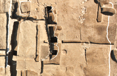
18. Excavation of the Archaeological Site at 410 Pungnap-dong and Discovery of a Baekje Wooden Well.
Discovery of wooden well of the Baekje Dynasty
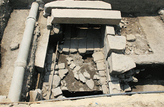
This archaeological site at 410 Pungnap-dong, Songpa-gu, Seoul extends 15-20m from the eastern wall of Earthen Fortification in Pungnap-dong, Seoul (cultural heritage-designated area), comprising some 15 adjoining lots. The area of the apartment redevelopment site measured 5,696㎡. Our research office conducted the excavation from July 26th to September 25th, 2004.
This area bordering the eastern wall ofEarthen Fortification in Pungnap-dong, Seoul, the objective of the trial excavation was to look for a former moat site and archaeological layers containing Baekje artifacts. Three shafts, measuring 12-14m in width and 24-45m in length, were dug for the purposes of this investigation. The ground was drilled to about 7.4m below the surface, revealing a fill stratum extending 2m underground. Although Baekje earthenware fragments were excavated, no evidence of ruins was confirmed.
 Condition of excavated artifacts from well no.3
 Earthenware used as a well bucket excavated from well no.4
 Condition of excavated artifacts from well no.4
 Southern wall of the wooden well
 Southwest side of the wooden well
 Additional view of wooden well after the investigation
A trial excavation was also performed in an area situated northeast of this site, near 336-1 Pungnap-dong, between March 25 and May 11, 2004. In this area, also slated for an apartment redevelopment project, the institute's archaeological team identified the vestiges of five Baekje-period installations, including a drainage duct and pits. The drainage duct was U-shaped and measured 11.2m long, 50cm wide, and 45cm at its deepest. The inlet was at the southern end of the duct, and the northern extremity of the duct was elevated from the ground by 37cm. The drainage system had a buried duct at the inlet and some middle sections. Above and inside the installation, shards of large jars and low-fired pottery lids were discovered. The pits were either rectangular or irregular in shape and contained a variety of Baekje pottery.
19. Dwellings in the Earthen Fortification in Pungnap-dong, Seoul.
Early Baekje capital hidden under modern apartment buildings
Located on the floodplain of the Hangang River in Songpa-gu, Seoul, Fortress Site is an earthen fortification 3.5km in circumference with a flattened oval shape. The first excavation started in 1997 when a large amount of Baekje earthenware shards were discovered at an apartment construction site within the fortress walls.
The excavation yielded 19 pit dwellings, several dozen storage pits and dumpsites, earthenware shards, kilns, and a triple-layer circular structure built in an earlier period than other artifacts.
 View of Pungnap 1st District
 View of Pungnap Sinu District after the investigation (Hwanho, dwelling)
 View of Pungnap Sinu District during the investigation (dwelling, pits)
 View of the pits after the investigation
This archaeological site was in better condition than any other Baekje site of the Hanseong Period discovered so far and excelled others in terms of the size and number of discovered artifacts. Discovery of the sites of hexagonal dwellings with a protruding entrance and fireplace built with clay and stone slabs provides important resources for study of the structure and changes in dwellings in the period. Over 1,200 artifacts were discovered during the excavation, including earthenware, tiles, bricks, iron implements, fishing net sinkers, spindle wheels and earthenware tubes, and are expected to provide important information on various aspects of early Baekje.
 View of the dwellings
 Earthenware products
 Large jar
 Samjokbae
 Convex roof-end tiles
 Vessel stand
 Bricks
20. Excavation Survey of the Surroundings of the Seated Rock-carved Bodhisattva of Uiseong.
In November 2010, the Research Division of Archaeology conducted an ad-hoc excavation survey to confirm the existence of buried cultural heritages in the vicinity of the Seated Rock-carved Bodhisattva discovered at the Uiseong Nakdanbo construction site, one of the Four Major Construction Project sections.
The Seated Rock-carved Bodhisattva was located on the northern ridgeline of Mangyeongsan Mountain, which divides Uiseong-gun and Sangju-gun at the borderline of the Nakdonggang River. Exposed to the left (downstream) of the Rock-carved Bodhisattva are the rocks (Yongbawi) stretching from Mangyeongsan Mountain. The right side (upstream) is adjacent to the slope of the existing road. When road expansion work was conducted in 1984, long after the road construction work conducted during the period of Japanese colonial rule, the rocks of Mangyeongsan Mountain were blasted, thereby covering the surroundings of the Bodhisattva with rocks and soil and concealing them. However, the rock confirmation survey carried out during the recent construction work on the retaining wall revealed the area.
Pre-excavation GRP surveys of the surroundings of the Bodhisattva confirmed the existence of construction stones in the area some 5-6m from the Bodhisattva, as well as a vertical cross-section slope. Electrical resistivity surveys revealed that there is a high resistivity zone in the area around 5-6m in front of the Bodhisattva and to a depth of 4~5m. This result was similar to that of the GPR surveys.
To confirm the existence of the worship space in front of the Bodhisattva, a survey was conducted by installing an exploration gallery measuring 8m in length and 3m in width. This revealed that a green safety network, installed in the recent construction process, was discovered in the banked earth layers. The area all the way down to a depth of 2.5m below the green safety network was filled with soil and large rocks that were presumably pushed towards the river after being blasting on the north side of Mangyeongsan Mountain in 1984. These rocks and soil layers were confirmed 9m under the road’s surface. In the process of removing the rocks and soil layers, a stone wall structure constructed before 1984 and located 2.6m in front of the Bodhisattva was identified.
This stone wall structure, which surrounds the Bodhisattva, was found to measure 5.5m in length and 4.2m in height (15 horizontal levels and 10 vertical levels), and was apparently built by piling wedge sized 20 to 40㎝ into lozenges and filling the interior with big natural stones and blasted stones. However, the surveys could not confirm the existence of other relics and remains related to the Bodhisattva.
Separately from this survey, following a report made by a resident, the possibility of additional buried cultural heritages existing in the vicinity of the Bodhisattva was confirmed. For the survey, an explorative gallery measuring 5m in length and 2m in width was installed 17m east of the Bodhisattva. In this area, rock layers had been confirmed 2.5m from the current slope when boring work was conducted on the retaining wall. Soil layers within the gallery were found to consist of the existing road surface and the banked earth layers. When removing the banked earth layers, the survey tried to expose the depth to the rock surface, but due to the danger of road collapse, the survey was stopped, and no remains or relics were found.
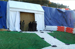 View of the frontal side of the Seated Buddha Carved on Rock Cliff before investigations
 The slope surface on the east side of the Seated Buddha Carved on Rock Cliff
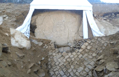 The frontal side of the stone column of the Seated Buddha Carved on Rock Cliff
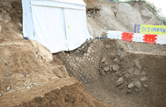 The frontal side of the stone column of the Seated Buddha Carved on Rock Cliff
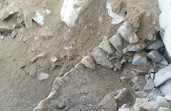 Upper side of the stone column of the Seated Buddha Carved on Rock Cliff
 The exposed condition of the lower part of the Seated Buddha Carved on Rock Cliff
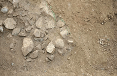 Soil layer condition of excavation tunnels of the frontal side of the Seated Buddha Carved on Rock Cliff (checking of green safety nets)
 The condition of 2 soil layers of excavation tunnels
